THE GUIANAS
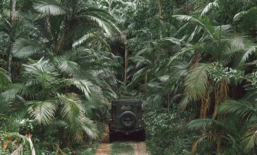
The Guianas form South America’s northeastern frontier — a dense shield of jungle, rivers and red-earth corridors where colonial history and rainforest geography intersect. Overex travels here for remote crossings, cultural contrast and the continuity of the trans-continental overland route. This is not high altitude. This is equatorial isolation — humid, layered and logistically demanding.
THE GUIANAS
TRAVEL SNAPSHOT
TERRITORRY
- • REGION: South America
- • CAPITAL CITY: Georgetown / Paramaribo / Cayenne
- • LANDSCAPE: Rainforest, river systems, coastal plains
- • ALTITUDE RANGE: Sea level – 1,200m
- • CLIMATE: Tropical humidity / heavy rainfall cycles
- • POPULATION DENSITY: Concentrated along the coast
- • OFFICIAL LANGUAGE(S): English / Dutch / French
- • LOCAL CURRENCY: Guyanese Dollar / Surinamese Dollar / Euro
EXPEDITION PROFILE
- • BEST SEASON: Drier months (regional variation)
- • REMOTENESS: Moderate - High
- • DRIVING CONDITIONS:Laterite roads, river ferries, border crossings
- • PACE OF TRAVEL: Slow / border-dependent
- • TRAVEL STYLE: Expeditions
- • DIFFICULTY: Moderate
- • LOCAL INTERACTION LEVEL: Moderate - High
- • ELECTRICITY: 110 / 220V
Antarctic Peninsula
OVEREX LATITUDE SERIES 2026 PARAMARIBO → IQUIQUE
EXPEDITION CONTEXT
• Sections of the historic Silk Routes
• Proximity to the Pamir Highway corridor
• Multiple passes above 3,000 m
• Seasonal road closures due to snow
• Limited infrastructure outside main valleys
FIELD NOTES
• Fuel planning required in remote regions
• Border permit requirements in certain areas
• Language barriers outside urban centers
• Weather volatility at altitude
• Limited recovery services in mountain zones

