OVEREX
Dune systems. Stone plateaus. Endless exposure.

THE SAHARA

ASIA

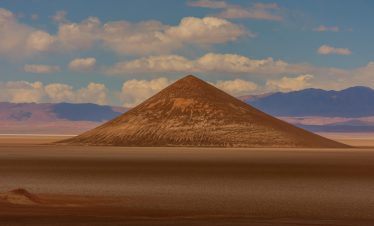
The Sahara is not a country — it is a system. A vast desert belt stretching across North Africa, shaped by wind, silence and geological time. Overex travels here for pure exposure: dune fields, dry riverbeds, rock hamada and open navigation where borders matter less than fuel range. This is not cultural travel. This is environmental commitment — distance, heat and self-sufficiency.

The Sahara crosses multiple North African nations. Overex routes operate across selected sectors depending on regional accessibility and permits.

Active Sectors

Morocco Western Sahara Mauritania Tunisia

Future Sectors

Algeria (planned expansion)
THE SAHARA

TRAVEL SNAPSHOT

ASIA

TERRITORRY

THE SAHARA
  • • REGION: North Africa
  • • CAPITAL CITY:
  • • LANDSCAPE: Erg dunes, hamada plateaus, dry wadis, gravel plains
  • • ALTITUDE RANGE: Sea level – 2,000m+
  • • CLIMATE: Extreme arid / high heat exposure / cold desert nights
  • • POPULATION DENSITY: Sparse
  • • OFFICIAL LANGUAGE(S):
  • • LOCAL CURRENCY:

EXPEDITION PROFILE

THE SAHARA
  • • BEST SEASON: October – April
  • • REMOTENESS: Very High (deep sectors)
  • • DRIVING CONDITIONS:Sand dunes, piste tracks, remote desert navigation
  • • PACE OF TRAVEL: Slow / terrain-driven
  • • TRAVEL STYLE: Expeditions
  • • DIFFICULTY: Hard
  • • LOCAL INTERACTION LEVEL: Low outside settlements
  • • ELECTRICITY: 220V
7% Off
$4280
$3999

Duration 14 Days
Difficulty Demanding
6% Off
$8995
$8495
$8266

Duration 12 Days
Difficulty Accessible
majestic andes mountains with llama
$2375

Duration 7 Days
Difficulty Remote
11% Off
offroad adventure in oman s rocky terrain
$2245
$1995

Duration 10 Days
Difficulty Remote

EXPEDITION CONTEXT

• Border transitions define routing options
• Fuel autonomy critical in remote sectors
• Permits required in selected regions
• Dune navigation and convoy discipline essential
• Extreme temperature management required
• Satellite communication standard in deep desert

FIELD NOTES

• Sand pressure management constant
• Wind reshapes dune lines overnight
• Navigation relies on GPS & terrain reading
• Limited mechanical support outside urban zones
• Self-sufficiency mindset required
• Long visual horizons — minimal reference points

Active Sahara Corridors

BACK TO AFRICA

CONTINUE EXPLORING

MORE OF AFRICA

MADAGASCAR              SENEGAL

MAURITANIA                 TUNISIA

MOROCCO                     SOCOTRA

WESTERN SAHARA